Know all about the district and cities, state boundaries, international boundaries of Uttarakhand through this map.
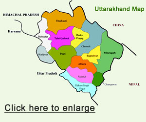
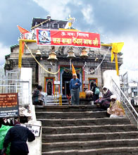
Uttarakhand is the 27th state of India carved out of Uttar Pradesh in November 2000. There are 13 districts in the state. Out of these 13, seven districts lie in the Garhwal region and the rest six in the Kumaon region. In total, there are 15,669 villages in Uttarakhand. Uttarakhand enjoys an exotic location being enveloped between the hills of the Himalayas. Its wonderful location, salubrious weather and serene environment makes its envious location for all other states in India. The states shares national as well as international boundaries. It has international boundaries with Tibet in North and Nepal in east. Within the country, it borders Himachal Pradesh in the North-west and Uttar Pradesh in the south.